Google Maps is fundamentally transforming how developers and businesses interact with its vast geospatial data, introducing a suite of advanced artificial intelligence features designed to streamline the creation of sophisticated, interactive mapping projects. These groundbreaking tools, powered by Google’s cutting-edge Gemini models, aim to democratize access to complex mapping functionalities, fostering a new era of customization and efficiency for a diverse range of applications.
For years, Google Maps has served as a ubiquitous digital compass, guiding billions of users globally and providing foundational location intelligence for countless businesses. Its evolution from a simple web-based mapping service launched in 2005 to a multifaceted platform incorporating satellite imagery, Street View, real-time traffic, and robust APIs has been continuous. This latest strategic pivot, deeply embedding generative AI capabilities, represents a significant leap forward, moving beyond mere data provision to intelligent content generation and contextual understanding within the geospatial domain.
The Dawn of AI-Assisted Map Building
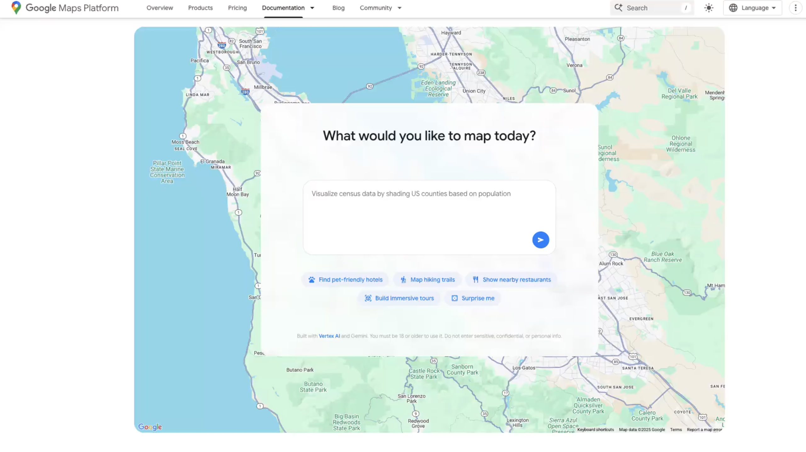
At the core of this new initiative are several key components, most notably the "builder agent." This innovative tool empowers developers to articulate their desired interactive map prototypes using natural language prompts, much like modern coding assistants. Instead of meticulously writing lines of code, users can simply describe the functionality they envision, such as "create a Street View tour of historic landmarks in Rome," "generate a map visualizing current air quality levels across major metropolitan areas," or "compile a list of accessible parks with picnic facilities in my vicinity." The builder agent then translates these textual descriptions into functional code, rapidly generating the foundational elements of the project.
This paradigm shift significantly lowers the barrier to entry for developing complex map-based applications. Historically, creating such interactive experiences required deep expertise in JavaScript, various Google Maps API services, and spatial data manipulation. Now, even those with limited coding knowledge can rapidly prototype sophisticated solutions, accelerating the development cycle from conceptualization to functional demonstration. Once the initial code is generated, developers retain full control, with options to export the code, test the preview project using their own API keys, or refine and expand upon the foundation within Google’s Firebase Studio, a comprehensive platform for building mobile and web applications.
Beyond functional generation, the new styling agent further enhances customization capabilities. This tool allows users to define a specific aesthetic or thematic style for their maps through descriptive prompts. Businesses, for instance, can now effortlessly create branded maps that align with their corporate identity, incorporating custom color palettes, icon sets, and visual themes. This ensures a consistent brand experience across all customer touchpoints, from a logistics tracking dashboard to a public-facing store locator, moving beyond generic map aesthetics to highly personalized visual storytelling.
Grounding AI in Real-World Context
A critical aspect of making AI truly useful in the real world is its ability to access and interpret factual, up-to-date information. Google addresses this challenge with "Grounding Lite," a feature building upon its existing map data grounding via the Gemini API. Grounding Lite introduces the Model Context Protocol (MCP), a standardized framework that enables various AI assistants to seamlessly connect with external data sources, including the rich datasets within Google Maps.
This capability fundamentally transforms how AI assistants can answer location-based queries. Instead of relying on generalized knowledge that might be outdated or imprecise, an AI assistant integrated with Grounding Lite can precisely answer questions like, "How far is the nearest grocery store from my current location?" or "What are the opening hours of the pharmacy closest to the central park?" The MCP acts as a bridge, allowing AI models to query Google Maps’ real-time, comprehensive spatial data to provide accurate and contextually relevant responses.
Complementing Grounding Lite is "Contextual View," a low-code Google Maps component designed to provide visual understanding alongside textual answers. When an AI assistant responds to a location-based query, Contextual View can dynamically present the information in the most intuitive visual format – be it a concise list of results, an interactive map highlighting relevant points of interest, or even a detailed 3D display for more immersive insights. This multi-modal approach ensures that users not only receive factual answers but also gain a clear spatial understanding, enhancing usability and decision-making.
Empowering Developers with Intelligent Assistance
Recognizing the complexities inherent in leveraging extensive API documentation, Google is also introducing the MCP server as a dedicated code assistant toolkit. This server connects directly with Google Maps’ technical documentation, providing developers with an intelligent interface to navigate and understand the intricacies of the Google Maps Platform APIs. Instead of sifting through pages of documentation, developers can pose questions in natural language, receiving instant, precise guidance on how to implement specific features, troubleshoot issues, or optimize their code.
This integration builds upon recent initiatives, such as the launch of extensions for Gemini’s command-line tool, which already enabled developers to access Maps data programmatically. The MCP server extends this assistance, offering a conversational interface that can explain API functionalities, provide code snippets, and offer best practices, significantly streamlining the development process and reducing the learning curve for new and experienced developers alike.
Broader Market and Societal Impact
The integration of advanced AI into Google Maps’ developer tools is poised to have a profound impact across various sectors.
For Developers and Startups: The democratization of complex mapping capabilities through low-code/no-code AI tools means that smaller teams and individual innovators can now build sophisticated applications that previously required extensive resources and specialized expertise. This could lead to an explosion of niche applications catering to specific local needs, innovative urban planning tools, or highly personalized travel guides, fostering greater competition and creativity within the geospatial tech ecosystem. The rapid prototyping capabilities afforded by the builder agent can drastically reduce time-to-market for new map-centric products and services.
For Businesses and Industries: Companies across logistics, real estate, retail, tourism, and transportation stand to benefit immensely.
- Logistics: Enhanced route optimization, real-time tracking visualization, and predictive analytics based on AI-interpreted traffic and weather data.
- Real Estate: More dynamic property search tools, interactive neighborhood guides, and AI-generated visualizations of property values or amenities.
- Retail: Customized store locators with detailed, context-aware information, personalized promotional maps, and improved supply chain transparency.
- Tourism: Creation of highly engaging, personalized tour experiences, interactive historical maps, and dynamic event guides that adapt to user preferences.
- Urban Planning: Tools for visualizing demographic data, traffic flow simulations, and environmental impact assessments, allowing for more informed decision-making.
The styling agent enables brands to integrate their visual identity seamlessly into their mapping solutions, strengthening brand recognition and providing a cohesive user experience. Meanwhile, the grounding capabilities ensure that AI-driven customer service tools or internal data analysis systems can leverage the most accurate and up-to-date geographical information.
For Consumers: While the primary focus of these new tools is on developers, the ultimate beneficiaries are consumers who will experience more intelligent, personalized, and visually engaging map-based interactions. The foundation laid by these developer tools will empower businesses and app creators to deliver richer experiences, potentially leading to more accurate navigation, context-aware recommendations, and visually stunning interactive content in their everyday digital lives. Google’s concurrent efforts to infuse Gemini-powered features directly into the consumer-facing Maps app, such as hands-free navigation and location-specific alerts in regions like India, further underscore this commitment to a more intelligent mapping future.
Analytical Commentary and Future Outlook
Google’s integration of Gemini across its Maps platform represents a strategic move to solidify its leadership in the geospatial domain amidst increasing competition from other mapping services and open-source alternatives. By embedding its flagship AI models directly into the developer workflow, Google is not just offering new features; it is redefining the entire development paradigm for location-based services. This approach aligns with a broader industry trend towards "AI-first" product development, where artificial intelligence is not an add-on but a fundamental layer driving core functionalities.
The shift towards low-code/no-code platforms, facilitated by generative AI, is a significant trend in software development. It democratizes technology by making powerful tools accessible to a wider audience, from seasoned developers looking for efficiency gains to business analysts and even citizen developers. However, this also raises questions about the quality and security of AI-generated code, necessitating robust testing and validation processes. Google’s provision for exporting and modifying the generated code in Firebase Studio acknowledges the need for human oversight and refinement, ensuring developers maintain ultimate control and accountability.
The emphasis on "grounding" AI models with real-world, authoritative data through protocols like MCP is crucial. It addresses a persistent challenge with large language models: the potential for "hallucinations" or generating plausible but inaccurate information. By ensuring AI assistants can query and integrate verified geospatial data, Google aims to enhance the reliability and trustworthiness of AI-powered location services.
As AI continues to advance, the synergy between powerful language models and comprehensive geospatial data promises to unlock unprecedented levels of innovation. From highly localized, intelligent search results to dynamic, adaptive urban infrastructure management systems, the potential applications are vast. Google Maps, through its deep integration of Gemini AI, is positioning itself not just as a map provider, but as a foundational AI platform for understanding and interacting with the physical world in increasingly intelligent ways. This move is less about incremental updates and more about laying the groundwork for a future where our digital interactions with places are intuitive, informed, and deeply personalized.


