Google Maps is set to significantly enhance its navigation capabilities across India, integrating its sophisticated Gemini artificial intelligence model alongside a suite of localized road safety and real-time information features. This comprehensive upgrade, following its initial rollout in the United States, represents a pivotal step in Google’s commitment to providing a more intuitive, safer, and contextually aware navigation experience for millions of users in one of the world’s most dynamic and challenging road environments.
The core of this evolution lies in the seamless integration of Gemini, Google’s generative AI, into the Maps application. This advancement brings a hands-free AI assistant directly into the navigation experience, allowing users to interact naturally with the app for information and guidance. Beyond simple directional prompts, Gemini will offer contextual suggestions based on the route and points of interest, enriching the journey with details about nearby landmarks, businesses, or cultural sites. For instance, a driver approaching a famous historical monument might receive a voice prompt offering a brief history or suggesting parking options, all without diverting their attention from the road. This deep AI integration is poised to transform how users discover and interact with their surroundings while navigating, moving beyond mere turn-by-turn directions to a more interactive and informative travel companion.
Tailored for India: The Localization Imperative
The deployment of Gemini and other new features in India is not a mere replication of global functionalities; it is a meticulously localized effort, as highlighted by Miriam Daniel, Vice President and Head of Google Maps. Daniel emphasized that "localizing for India is not just the language," but rather a profound adaptation to the unique ways Indian users interact with technology, the distinct linguistic nuances, the identification of places, the complex geopolitical landscape, and the myriad variations in street names and addressing systems. This deep understanding underscores the complexity of mapping a nation as diverse as India, where geographical, cultural, and linguistic variations are immense.
India’s digital landscape has undergone a remarkable transformation over the past decade. With widespread smartphone penetration and affordable data, millions have come online, making digital services an integral part of daily life. Google Maps has been a key enabler in this digital revolution, becoming the de facto standard for navigation for personal travel, public transport, and the burgeoning gig economy. The platform’s ability to adapt to local conditions, from displaying auto-rickshaw routes to integrating public transit schedules, has been crucial to its success. The new Gemini integration will initially support nine Indian languages, ensuring that a significant portion of the country’s diverse linguistic population can access these advanced features in their native tongue, thereby fostering greater digital inclusion and accessibility.
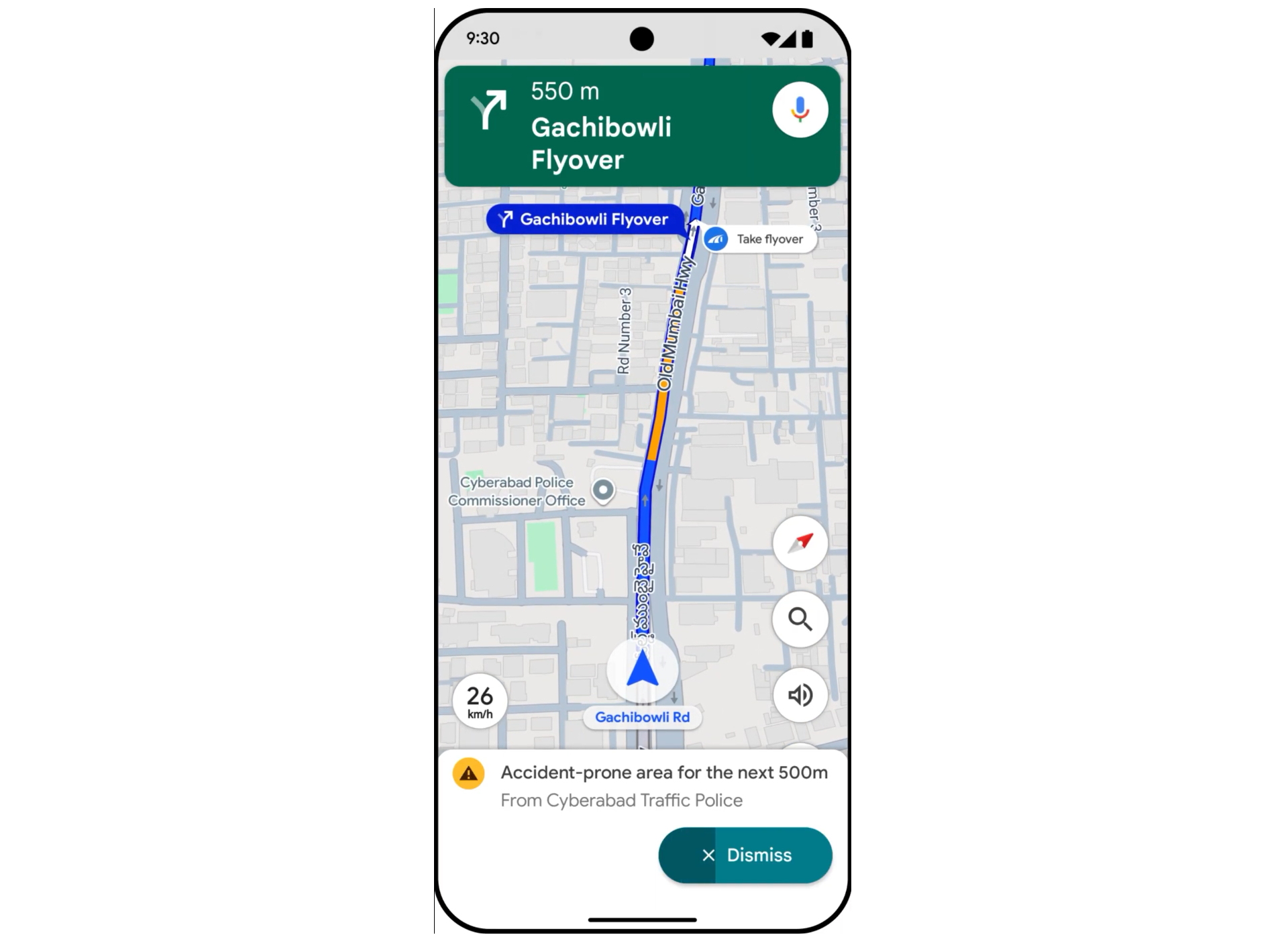
Enhancing Road Safety: Proactive Alerts and Real-time Data
A critical component of this update focuses on improving road safety, a pressing concern in India where road accidents remain a significant public health challenge. Google Maps will now provide drivers with visual and audio alerts when they approach stretches of road identified as accident-prone. This proactive warning system is a direct response to the need for greater awareness on hazardous routes. The initial rollout of these accident-prone alerts is concentrated in specific high-traffic regions: Gurugram, the Cyberabad region of Hyderabad, Chandigarh, and Faridabad, signaling a targeted approach based on local accident data and traffic patterns.
To bolster the accuracy and timeliness of its information, Google has forged a crucial partnership with the National Highways Authority of India (NHAI), the country’s apex body for highway development and maintenance. This collaboration will enable Google Maps to receive near real-time data on critical road conditions, including closures, diversions, and ongoing repair work. This direct data feed from a primary infrastructure authority is a game-changer, addressing a longstanding challenge of rapidly updating map data in a country with continuous infrastructure development. Beyond safety and route efficiency, the NHAI partnership will also enrich the navigation experience by displaying essential wayside amenities such as public restrooms, restaurants, and fuel stations along national highways, a feature of immense practical value for long-distance travelers.
Furthermore, Google Maps will introduce proactive notifications about major disruptions or delays on planned routes, even when users are not actively navigating. These early warnings, rolling out to Android users for highways and major roads in bustling metropolitan areas like New Delhi, Mumbai, and Bengaluru, allow commuters to make informed decisions about their travel plans, potentially saving significant time and reducing frustration. The app will also display speed limits during navigation, leveraging data from local traffic authorities. This feature is being rolled out in nine major cities, including Faridabad, Ghaziabad, Gurugram, Hyderabad, Jaipur, Kolkata, Lucknow, Mumbai, and Noida, providing drivers with crucial information to adhere to traffic laws and enhance safety. Building on the visual flyover navigation introduced last year, the app is now adding voice support for flyovers, further simplifying navigation through India’s complex multi-layered road infrastructure.
A History of Innovation: Google Maps in India
Google Maps’ journey in India reflects a continuous evolution driven by local needs. Launched globally in 2005, its presence in India quickly became indispensable. Initially, it provided basic mapping services, but over the years, Google has invested heavily in features tailored specifically for the Indian market. This includes the introduction of two-wheeler mode, recognizing the dominance of motorcycles and scooters on Indian roads, and public transport integration that covers vast and varied networks from metro systems to local buses. The "Plus Codes" initiative, which assigns simple alphanumeric codes to any location without a traditional street address, addressed the challenge of informal or non-standardized addressing prevalent in many parts of the country.
However, this journey has not been without its challenges. The dynamic nature of India’s infrastructure, with rapid construction and frequent changes, poses an ongoing hurdle for mapping accuracy. A tragic incident late last year, where a car drove off an unfinished bridge in Uttar Pradesh, resulting in fatalities, brought Google Maps under scrutiny regarding the reliability of its navigation routes. Anal Ghosh, a senior program manager for Google Maps, acknowledged the inherent difficulties, stating, "The real-world conditions can keep changing, and it’s very dynamic, and sometimes it changes in an instant. Maps can’t be accurate 100% of the time." This statement underscores the continuous need for robust data partnerships and user feedback to maintain accuracy in such a fluid environment. The new partnership with NHAI is a direct and strategic response to this challenge, aiming to bridge the information gap with official, near real-time data.
Broader Implications: Market, Society, and Future Commutes
The introduction of Gemini and enhanced safety features carries significant market, social, and cultural implications for India. From a market perspective, these upgrades reinforce Google Maps’ dominant position in the navigation sector. By offering highly localized and AI-powered features, Google aims to further entrench its user base and potentially attract new users who prioritize safety and convenience. This move also sets a higher bar for competitors, compelling them to invest more in localized AI and real-time data integration.
Socially, the impact could be profound. For daily commuters, the proactive alerts for disruptions and accident-prone zones can reduce stress and improve safety, potentially contributing to a reduction in road accidents over time. For the burgeoning gig economy, including delivery riders and ride-sharing drivers, more accurate and safe navigation tools mean increased efficiency and reduced risk, directly impacting their livelihoods. Culturally, the support for multiple Indian languages in Gemini ensures that these advanced technological benefits are not limited to English speakers, promoting digital equity across diverse linguistic groups. For domestic and international tourists, enhanced navigation with contextual information about places of interest could significantly improve their travel experience, making exploration easier and more insightful.
Navigating the Future: Challenges and Opportunities
While the new features represent a significant leap forward, challenges persist. The sheer scale and diversity of India mean that maintaining 100% accuracy and real-time updates across all roads, especially in remote or rapidly developing areas, will remain a monumental task. User adoption of the new AI features will also be critical; while Gemini offers powerful capabilities, users will need to adapt to interacting with AI for navigation. Furthermore, while technology can enhance safety, it cannot replace driver vigilance, a point Google itself emphasizes. The cultural habit of relying heavily on navigation apps sometimes at the expense of situational awareness is a broader societal issue that technology can only partially address.
Looking ahead, these updates open numerous opportunities. The foundation laid by Gemini’s integration could pave the way for even more personalized and predictive navigation experiences. Imagine Maps not only suggesting routes but also anticipating a user’s needs based on their past behavior, calendar, or even current weather conditions. The partnership with NHAI could expand to include more granular data, such as real-time updates on parking availability or localized traffic enforcement. As India continues its rapid infrastructure development and digital transformation, Google Maps, armed with advanced AI and dedicated localization efforts, is positioned to remain an indispensable tool, constantly evolving to meet the complex demands of its vast user base.